")


Development of a seismo-gravimetric model of the crust of North-Eastern Italy
Solid Earth Sciences, Seismology
Research area
Northeastern Italy is a seismically active region where the Eurasian plate, Adria microplate, and Pannonian fragment interact.
Accurate crustal models are crucial for understanding fault structures and seismic hazard assessment.
This project refines the North Adria Crustal Model (NAC) by integrating new seismic and gravimetric data, improving subsurface imaging resolution.
The updated 3D model will also enable better relocation of past and future earthquakes in Friuli, enhancing the understanding of seismic sources and regional tectonics.
This initiative, led by OGS in collaboration with the National Institute of Geophysics and Volcanology (INGV), the University of Genoa and the Geological Service of the Autonomous Province of Trento, supports seismic risk mitigation and geological hazard assessment.
Project goals
The project focuses on refining and updating the crustal model of northeastern Italy and its surroundings by integrating high-resolution seismic tomography and gravimetric data. The primary challenge lies in improving the accuracy of existing models, which currently suffer from data gaps and resolution limitations.
The project addresses these issues by:
- incorporating an updated earthquake catalog and new gravimetric data to enhance model accuracy;
- developing Python-based computational tools for data integration and geophysical modeling;
- implementing a 3D velocity model to improve earthquake localization and simulate seismic scenarios;
- performing iterative tomographic-gravimetric inversions to refine subsurface structure resolution progressively.
Computational approach
The project relies on advanced computational techniques to process large geophysical datasets and perform complex inversions.
Key technological challenges include:
- combining multi-source geophysical data (seismic, gravimetric, borehole) into a cohesive, high-resolution model;
- implementing parallel computing and HPC resources (CINECA) to handle the computational demands of 3D tomographic-gravimetric inversions;
- designing and optimizing Python-based tools to interface with modeling software, ensuring scalability and reproducibility;
- iterative inversion techniques require significant computational resources to progressively enhance accuracy and resolution;
- probabilistic earthquake localization using 3D velocity models, which demands extensive memory and parallel computing resources for efficient computation.
By leveraging high-performance computing (HPC) and parallel processing techniques, the project aims to overcome these challenges, enabling the development of a robust, data-driven seismic model. The tools and methodologies developed will be shared with the broader geophysical research community, promoting advancements in seismic and crustal studies.
Image
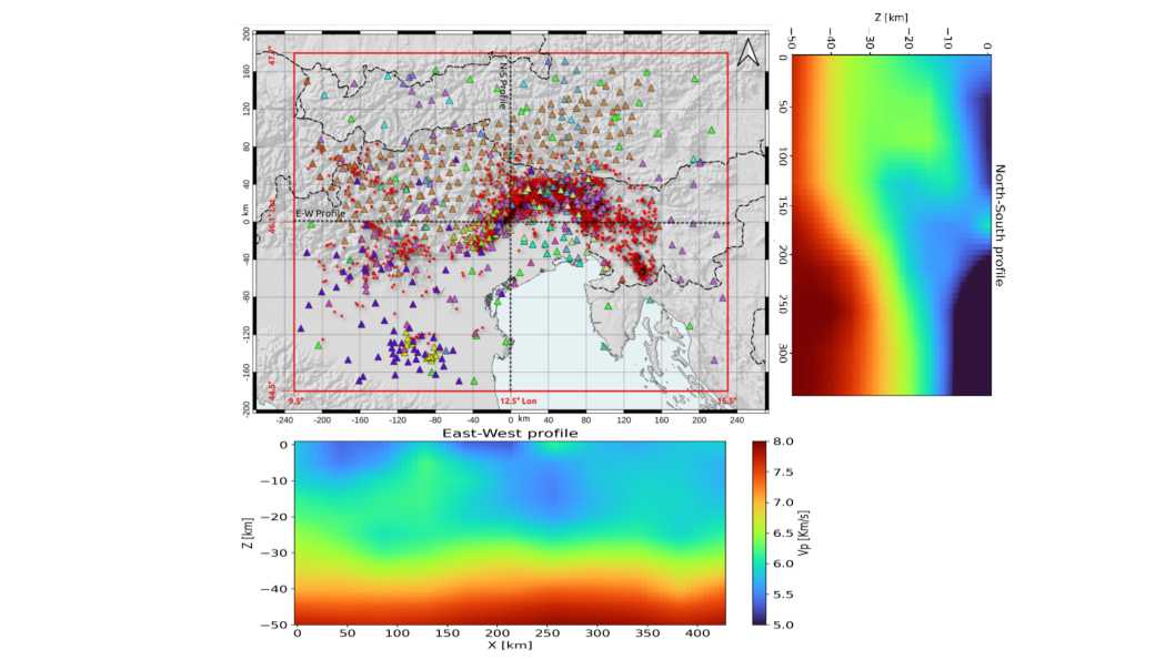
The figure shows the study area of the tomographic model for northeastern Italy. The central map displays seismic stations (triangles, color-coded by network) and earthquakes (red dots) from the 1988–2021 catalog.
The bottom panel presents an East-West velocity (Vp) section, while the right panel shows a North-South section, highlighting subsurface variations obtained through an optimized inversion process parallelized on Galileo100 HPC.
Luigi Sante Zampa
Istituto Nazionale di Oceanografia e di Geofisica Sperimentale
I hold a Bachelor's degree in Geology and a Master's in Geosciences (Geophysics) from the University of Trieste. I earned a PhD in Earth Sciences, Fluid-Dynamics, and Mathematics, focusing on gravity data acquisition, analysis, and modeling for tectonic reconstruction. I have worked at the National Institute of Oceanography and Geophysics (OGS) and as a scientific assistant at BGR (Germany), specializing in gravimetric and geomagnetic data for mineral exploration. Currently, as a postdoctoral researcher at OGS, I integrate seismological and gravity data for seismic tomography and inverse modeling. I have expertise in Python, MATLAB, Fortran, and C for scientific computing, as well as GIS data analysis. I lead the ISCRC project at CINECA, "Development of a seismo-gravimetric model of the crust of North-Eastern Italy," leveraging HPC resources for high-resolution crustal modeling.